St. Petersburg, the seat of the Romanov dynasty, became Leningrad, and then again St. Petersburg. Kaliningrad is the former easternmost German city of Koningsburg, seat of the Hohenzollern Prussian dynasty and its brief empire.
The first city was not founded, no not founded, but was created – think about that – literally created by Tsar Peter I, Peter the Great – to give Russia trade and naval access to the Baltic Sea and the world beyond. It one of the two bases of the Russian Baltic Fleet. It is ice free only part of the year.
The second of the two, Kaliningrad, a German city for hundreds of years, was ceded to the Soviet Union by the WWII Potsdam agreement between the USSR, England and the United States in late 1945. In 1946-1947 all Germans were expelled, replaced mostly by Russians but also Balts and Ukrainians.
Wedged on today’s European map between Lithuania and Poland, 400 miles west of present day Russia, it is the headquarters and the other main base of the Russian Baltic Fleet. It is mostly ice free year around.
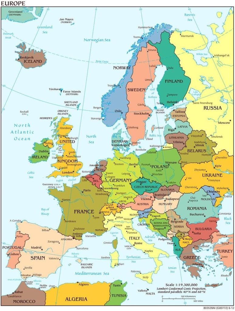
This map shows the Baltic Sea and the nations on its shores. Notice St. Petersburg, east of the Baltic Sea through the Gulf of Finland (located on the map just above and east of Estonia) and Kaliningrad to the west, the small territory shown in yellow between Lithuania and Poland.
With the acceptance and admittance first of Finland and now of Sweden to membership, the Baltic has become the NATO Sea.
For the first time in history nearly every shore on the Baltic Sea belongs to one alliance, in this case formed in the first place to check the power of the Soviet Union and – since Soviet disintegration 32 years ago – to balance naval power in the Baltic region with that of the successor state, Russia.
Over centuries one kingdom or empire or another dominated the Baltic but none ever controlled it virtually entirely. Sweden, Poland, Germany all had their turns in the 16th, 17th, 18th and 19th Centuries.
Except for the narrow entrance to the Baltic throught the Gulf of Finland, and at Kaliningrad, Russia now has no access to the Baltic.
Once its submarines and Baltic fleet sailed from the ports of the Baltic nations when after WWII they were incorporated in the USSR. Once, after German naval power was destroyed during WWII, it dominated the Baltic. No longer.
One of the greatest strategic changes in the history of Europe, on the map of Europe has taken place now, right now, with the advent of Swedish membership in NATO, joining Finland in the alliance in an achievement engineered by the United States.
It is as briliant a diplomatic and military undertaking and accomplishment of any American presidency and administration ever – ever.
It would be admired by Franklin Delano Roosevelt, the undisputed canny architect of post-WWII American world hegemony.
Accomplisehd by the administration of President Joseph R. Biden, this is a monumental historical moment for Europe with antecedents as long ago as 500 years.
No matter where you look now on the shores of the Baltic except Kaliningrad, there is a NATO Nation.
For the first time in more than 300 years, anything that Russia does in the Baltic will be watched, monitored, and opposed if it must be by a single, united adversarial force.
Russia’s Baltic Sea access and access beyond to the North Sea and the Atlantic Ocean is now circumscribed. Except for the neutral small Republic of Ireland in the North Atlantic, there is not a Russian allied shore on any of them.
This map shows NATO’s ascendant position now on the Baltic. Notice particularly (highlighted in purple) the Kaliningrad enclave separated from Russia proper by the three Baltic nations and then the Russian access through the Gulf of Finland, and how strategically diminished those points are on what is now otherwise a sea ringed by eight NATO nations.
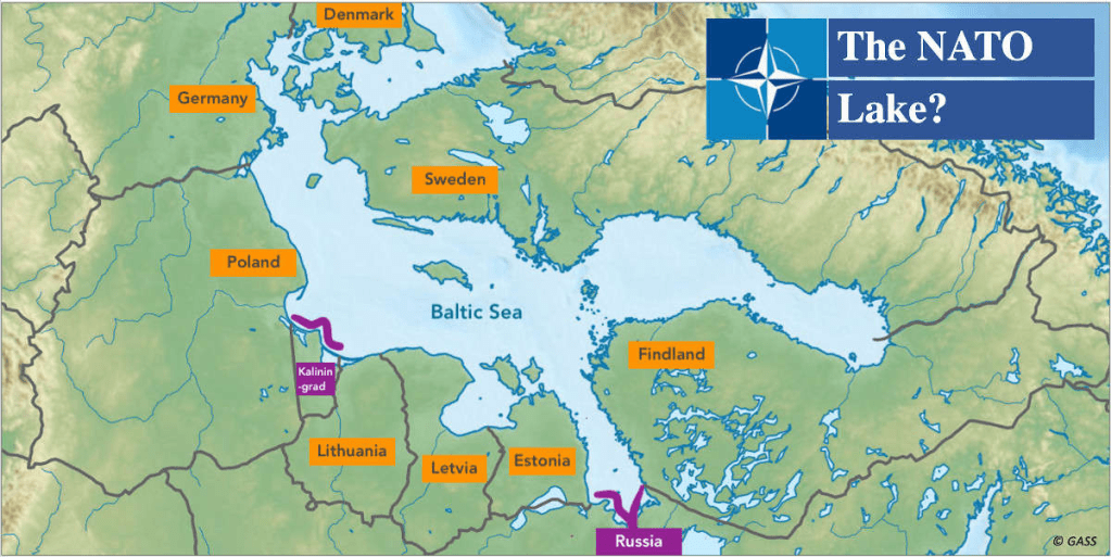
If a picture is worth a thousand words, this map says far more than that.
